The NCWFHC is collaborating with the OWNF to explore development of a long-term stewardship contract for the Chumstick-to-LP Planning Area, which is also one of DNR’s priority landscapes.
This planning area extends from Chumstick Creek in the north to Lower Peshastin (LP) Creek in the south. The area is popular for tourism and recreation and includes Leavenworth and other communities in the Wenatchee River corridor. The planning area is evenly divided between public and private ownership, with 51% of the total being USFS land.
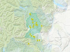
Fire risk is very high to extreme across the northern portion and southwest corner of the planning area, representing some of the highest risk areas in eastern WA (Fig. 2).
Projected warming over the next 20-40 years will likely shift climate conditions suitable for moist forest towards conditions suitable for dry forest. Low elevation areas, including much of the central portion, may no longer support forest.
Treating 43-63% of forested acres (36,500 to 53,000 acres) is recommended to increase resilience and reduce fire risk to communities using a combination of mechanical, prescribe fire, and managed wildfire treatments.
High priority areas for potential treatments that maximize forest health and wildfire response benefit include locations in the northern portion on both sides of the Chumstick Highway.